
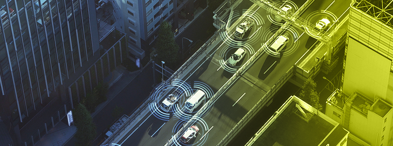
A deer steps into an unlit road at night. A human driver might not see it until it is too late. A vehicle running modern sensors can detect it earlier, but the three main perception sensors do not read that deer the same way. Each one reads the world through a different physical principle, and each is strong precisely where another falls short.
This article is the head-to-head comparison of those three sensors: how each one works and where they genuinely differ. The focus is automotive and ADAS perception, though the same sensors also guide drones over mapped terrain and mobile robots on the move.
Key Takeaways:
- Cameras are the only sensor that reads color and text, which makes them essential for signs and signals, but they depend on available light and infer distance instead of measuring it.
- Radar measures distance and closing speed directly and stays reliable in conditions that blind a camera, such as fog or darkness, at the cost of low resolution and weak object classification.
- LiDAR builds a precise 3D map in any lighting, but it costs more and loses accuracy in fog and snow.
How Does a Camera Work?
A camera is the sensor closest to human sight. It captures light through a lens onto an image sensor, producing a stream of pictures that software then interprets. On its own, that image is just pixels. The intelligence comes from computer vision models that read those pixels and label what they contain: a lane marking, a traffic light, a pedestrian, or the deer at the edge of the road.
What sets the camera apart from the other two sensors is that it reads the world in color and detail. It is the only one of the three that can tell a red light from a green one, read the text on a road sign, or recognize the shape of an animal well enough to classify it.
And its limitation follows from the same principle. A camera depends on light it does not control. In darkness or when something blocks the lens, its input degrades the same way a human driver's vision would. It also captures a flat image with no built-in sense of distance, so depth must be inferred by software rather than measured directly. For the deer on the unlit road, that is the crux: the camera can identify the animal once it has enough light, but in full darkness it may not register it in time!
Camera Pros
- Captures high-resolution images for detailed object recognition.
- The only sensor that reads color and text, which is what makes traffic lights and road signs legible.
- Relatively low cost and small enough to integrate discreetly.
- Strong fit for vision tasks such as lane keeping and driver monitoring.
Camera Cons
- Performance drops in poor lighting or glare.
- Cannot measure distance or speed directly, so depth has to be inferred by software.
- Needs significant image processing and computing power.
- Easily obstructed by dirt or other contamination on the lens.
How Does Radar Work?
Radar works by emitting radio waves and listening for their reflection. When those waves strike an object, part of the signal bounces back to the sensor. By measuring how long the return takes and how its frequency shifts, the system calculates both the distance to the object and the speed at which it is moving.
That second capability is what makes radar distinctive since it reads velocity directly rather than inferring it from successive frames the way a camera must. Most automotive radar today operates in the 77 GHz band, whose short millimeter-scale wavelength gives finer range and velocity resolution than the older 24 GHz systems it has largely replaced.
Its great strength is reliability in conditions that defeat optical sensors. Radio waves pass through rain, fog, dust, and darkness with little loss, so radar holds its accuracy where a camera would struggle. It also performs well at long range, which is why it anchors highway-speed features such as adaptive cruise control and forward collision warning.
Radar confirms that something solid is present and how fast it is closing, but it paints a coarse picture. It cannot read a sign, and it struggles to tell one object from another when they sit close together. If we go back to our example of the deer on the road, radar is the sensor most likely to detect that something is there in the dark, even before the animal is visible. What it cannot do is confirm that the mass ahead is a deer rather than a boulder at the roadside.
Radar Pros
- Measures object distance and closing speed directly, the latter from the Doppler shift.
- Stays reliable in darkness and adverse weather such as rain or fog.
- Detects at long range, which suits highway-speed features such as adaptive cruise control.
-
Compact and easy to hide behind a bumper or fascia, at relatively low cost.
Radar Cons
- Lower resolution and weaker classification than a camera.
- Limited ability to identify what an object actually is.
- Can produce false detections from reflections or clutter.
- Cannot read lane markings or traffic signs.
How Does LiDAR Work?
LiDAR, short for Light Detection and Ranging, works on the same echo principle as radar. Radar uses radio waves, measured in centimeters down to millimeters. LiDAR uses near-infrared light near the 900-nanometer range, a wavelength roughly ten thousand times shorter, which is what lets it resolve millimeter-to-centimeter detail where radar stays at meter scale.
Every return becomes a point in space, and together those points form a dense three-dimensional map of the surroundings called a point cloud.
Where a camera infers depth from a flat image and radar approximates shape, LiDAR measures distance and geometry directly. For the deer on the unlit road, LiDAR traces the animal's exact outline in three dimensions, whether the road is lit or pitch dark.
LiDAR Pros
- LiDAR captures the precise position and contour of objects directly rather than estimating them, resolving detail fine enough to pick out something as slender as an overhead wire.
- Because it carries its own light source, it performs the same on a dark road as in daylight, which is exactly where a camera falls short.
- That mapping precision reaches well beyond the car! It drives drone-based aerial surveying across forestry, mining, archaeology, and civil engineering, and it guides mobile robots as they navigate and avoid obstacles.
LiDAR Cons
- >LiDAR units have historically been costlier and bulkier than cameras or radar, although both have fallen as the technology matures.
- Fog and heavy precipitation such as rain or snow scatter the laser pulses and blur the returns, cutting accuracy in the very conditions where radar stays dependable.
- It reads shape and distance but not color, so like radar it cannot interpret a traffic light or a road sign on its own
- It only detects what its pulses can reach, so an object hidden behind another stays invisible until it moves into view.
What is the Difference Between Radar and LiDAR?
Radar and LiDAR share the same basic idea. Both send out a signal, wait for it to reflect off objects, and measure the return to locate what is around the vehicle.
The main difference is the wavelength each one uses. Radar uses radio waves, measured in centimeters down to millimeters. LiDAR uses near-infrared light, with a wavelength thousands of times shorter. A shorter wavelength resolves finer detail, which is why LiDAR draws a sharp three-dimensional outline while radar returns a coarser one. At a range of 100 meters, radar typically resolves objects to within several meters, whereas LiDAR resolves to within a few centimeters.
The second difference is weather tolerance. The same long wavelength that limits radar's resolution lets its signal pass through fog and precipitation with little loss, while those same conditions scatter LiDAR's laser and blunt its accuracy. Radar holds up in weather that blinds LiDAR.
The third difference is what each measures best. Radar reads velocity directly from the frequency shift of the return, so it excels at knowing how fast something is closing. LiDAR reads geometry, so it excels at pinning down an object's exact shape and position.
Neither reads color or text, which is the gap a camera fills.
Back on the dark road, radar flags the deer's presence and speed at distance and through bad weather. LiDAR confirms the precise shape and location of whatever is there.
Camera-Based vs. Radar-Based ADAS: What Actually Changes?
At the sensor level, the camera stands apart from both LiDAR and radar because it is passive. It reads only the light the scene offers, while the other two supply their own signal and measure what returns, which makes them active sensors. That is why a camera alone reads color and text yet loses reliability in darkness or glare, whereas LiDAR and radar keep working even without it.
The same split shapes how ADAS is designed. Some systems treat the camera as the primary sensor and rely on vision and machine learning for most perception, which keeps cost and packaging low and reads signs and signals natively. Others build around radar, often with LiDAR alongside, so the vehicle keeps a dependable read when vision degrades at night or in bad weather.
What actually changes between the two is redundancy. A camera-based design is only as strong as its visibility, so a blinded or dazzled lens leaves little to fall back on. A radar-based design adds a weather-tolerant source that confirms distance and closing speed even when the camera cannot see.
The ADAS industry remains divided on where to draw the line. The right balance usually comes down to the conditions a vehicle has to handle.
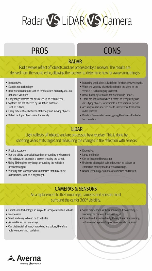
Radar vs. LiDAR vs. Cameras at a Glance
| Attribute | Camera | Radar | LiDAR |
|---|---|---|---|
| Working principle | Passive; captures ambient light on an image sensor, read by computer vision | Active; emits radio waves and measures the reflected signal | Active; emits near-infrared laser pulses and measures time of flight |
| Measures directly | 2D image and color; depth inferred by software | Distance and velocity, from the Doppler shift | Distance and 3D geometry, as a point cloud |
| Reads color and text | Yes | No | No |
| Resolution and detail | High, in two dimensions | Low, coarse returns | High, in three dimensions |
| Effective range | Tied to optics and available light | Long; up to roughly 250 m for automotive long-range radar | Moderate to long; shortens in poor weather |
| Low light and darkness | Poor; depends on available light | Unaffected | Unaffected |
| Adverse weather | Degraded by rain, fog, and glare | Robust; radio waves pass through fog and precipitation | Degraded; laser scattered by fog and precipitation |
| Object classification | Strong; recognizes signs and classifies object types | Weak; registers presence and motion but struggles to tell objects apart | Moderate; precise shape without color or text |
| Size and integration | Small and easy to conceal | Compact; hidden behind bumper or fascia | Larger, though shrinking as the technology matures |
| Relative cost | Low | Low to moderate | Higher, though falling |
| Primary role | Scene understanding and reading signs | Weather-tolerant detection of distance and speed | Precise 3D mapping and localization |
Do You Really Need All Three Sensors?
You might have understood by now that no single sensor covers every condition, because each one is strong exactly where another is weak. That is the whole case for combining them. On the dark road, radar flags that something is ahead and closing, the camera classifies it as an animal once there is light, and LiDAR fixes its exact position and size. Three partial readings become one dependable picture.
Merging those inputs into a single coherent model is the job of sensor fusion, which carries its own engineering and validation challenges. We cover how that arbitration works, and how full autonomy builds on it, in our guide to how autonomous driving systems work.
How Do You Make Sure These Sensors Perform as Intended?
Choosing the right mix of sensors is only half the problem. The other half is proving that the combined system behaves the way it should when conditions turn against it. Sensor testing and validation span the individual sensor, checking that a radar, camera, or LiDAR meets its performance targets. This is the foundation that automotive test and measurement programs are built on, and it becomes its own specialized effort in ADAS sensor validation.
Averna works with automotive OEMs and suppliers on these challenges. To discuss your own program, speak with one of Averna's experts.

You may also be interested in…
To see how this plays out in production, our case study on automotive radar production testing shows the approach applied at scale


